Maps/DA Signs

NEW MAP showing properties affected by noise, dust and odour. Click here
Plan of the proposed broiler sheds and infrastructure. Click here
Plan of the haul route. Click here
Map with the rivers and roads marked and radius circles. Click here
Map of the district with the proposed broiler farm boundaries marked in red. Click here
Aerial view of the district with the proposed broiler farm boundaries marked in red. Click here
Advertising the Development Application
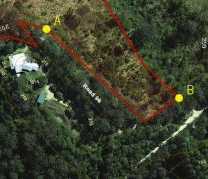
Locations of signs A and B in relation to Top Forestry Rd
The developer’s Notice of Compliance of Public Notification posted on the council website, and that the developer placed an advertisement in the Sunshine Coast Daily on Tuesday 14 May 2013. Letters were also sent to neighbouring properties.
Also, there are photographs of DA signs announcing the development that were noted to have been placed on the property. The covering letter states that the signs were placed “on the land in the way prescribed under the Sustainable Planning Act 2009 from 14th May to 5th June 2013”.
We allege that the DA signs on the 136 Top Forestry Road property did not follow the state government guidelines as stated HERE. Section 16 of the SPR clearly states that one of the requirements for placing a notice on the land is that it be: “positioned so that it is visible from the road”.
Watch our video below for an explanation of where the signs were located.
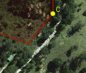
Location of sign C in relation to Top Forestry Rd.
Maps tell the story
A map marking the location of the four DA signs obtained from the developer (HERE) on which we have coded the location asterisks A,B,C and D, clearly shows that the two signs on Top Forestry Road (B & C) could not have have been seen from the road, since they are marked as being located on the property boundary, but down embankments and behind roadside vegetation. And sign A was located on an unused, vegetated road easement near the developer’s house, while sign D was well away from Top Forestry Road and inaccessible to all but bushwalkers and horseback riders in a remote part of the adjoining state forest.
Legal advice was sought on behalf of four affected West Cooroy residents who did not see any signs during the period they were supposed to have been in place from 15 May to 4 June. The reply can be read HERE.
Despite the threat to sue us, we may take this matter further should we wish to obtain third party rights to the applicant’s legal appeal to Council’s decision to reject the broiler farm.